Edit properties of vector features
Properties hold additional information about features. They’re useful for adding extra information to each feature in a dataset, and you can define as many as you need.
Properties are added on dataset level, not on indiviual feature level. This means that you can define your properties even before you add the first features to your dataset, but in practice you’ll often add geometries first and then think about what properties you need for them. Either way, once you define a new property, you can use it for every feature in the dataset.
Add new property
-
In the left menu, open Settings.
-
Under Properties, click the Add button.
-
Fill in the property key (name) and select type:
- String stores textual data. Use it for names, dates, alphanumeric IDs, and any other data that should be treated as text.
- Number stores numerical values. It’s useful to be consistent with the value format, for example, use
1.0instead of1if you want floating point numbers. - Boolean stores one of the two possible values:
trueorfalse.
-
Optionally, add a default value for all features in the dataset. Any existing or newly added feature will use this value, unless you change it.
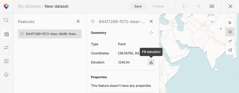
Calculate elevation
Basic geometry description also includes elevation of a point, that is, the height of the point above mean sea level. Elevation isn’t filled in by default, but you can add it to any feature manually.
-
In the left menu, open Features and select a feature.
-
Under Geometry, click Fill elevation to add the value.
In case of lines and polygons, the system will fetch elevation of all nodes that don’t have it yet, and calculate the average elevation for the whole feature. This can be many nodes, so you may want to simplify your feature first.
What’s next?
With your dataset ready, it’s time to add the features to your map.