Modify your vector features
After you upload an existing dataset or add new vector features, you can modify the features. This page explains how to change their geometry (shape or position). To modify properties, see editing properties.
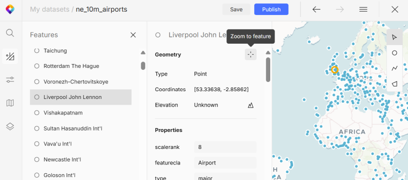
Zoom to feature
To be able to edit a feature, first you need to find it on the map, which gets challenging in a large dataset with many features. Here’s how to make it easier:
-
In the left menu, open Features.
-
In the list, select the feature you want to edit. Note that search in the menu is for searching the map, not your list of features.
-
Under Geometry, click Zoom to feature. The map will smoothly move and zoom into the right place. (Alternatively, right-click on a feature and select Zoom to feature from the context menu.)
Select feature or nodes
To select one or more features:
-
Open the Features list.
-
Right-click on a feature to show the context menu and click Select in map. For multiple features, first hold down
ShiftorCtrlto select them in the list and then use the right-click.
To select specific nodes in a line or polygon:
-
In the tools panel on the right, activate the Select mode.
-
Click on the desired nodes in the feature. Hold down
Shiftto select consecutive nodes orCtrlto cherry-pick nodes.
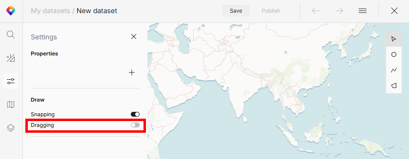
Move features
Moving features is by default turned off, so first you need to enable it:
-
In the left menu, open Settings.
-
In the Draw section, enable Dragging. Note that if there are many properties, the Draw section will be at the bottom.
-
Select the feature or individual nodes you want to move, and drag them to a new position.
Duplicate features
-
In the left menu, open Features.
-
Right-click on a feature to show the context menu and click Duplicate.
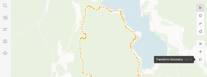
Transform features
The editor also offers advanced methods to transform your lines and polygons:
-
Select the features or individual nodes you want to transform and click Transform geometry.
-
Select the transformation method: Simplify or Smoothen.
Simplify
Simplification removes points (nodes) from a feature. This is handy if the feature is too detailed, for example if the points are created by a GPS tracking device. Adjust the tolerance to see how many points there will be in the simplified result.
Simplification works best for shapes with many excessive nodes that don’t improve precision. Removing these nodes makes no visible difference and the feature is easier to work with. Also, you need fewer API requests to calculate elevation. However, keep in mind that horizontally straight lines aren’t necessarily flat vertically, and simplification might reduce accuracy that’s critical for elevation profiles and terrain analysis. Consider your needs and keep enough nodes to preserve meaningful detail in your data.
Smoothen
Smoothening adds points (nodes) to a feature. This method is helpful when you’ve created your lines or polygons by hand and want to change their pointy edges into smooth curves for a more polished look.
-
Smoothening lines provides better results if applied to specific nodes rather than a whole line. Sharpness determines how round the edges will be.
-
Smoothening polygons adds new nodes evenly between existing nodes. Levels determine how many nodes will be added per edge, with each level doubling the count.
Delete features
-
In the tools panel on the right, activate the Select mode.
-
Select the feature or individual nodes you want to delete.
-
Use the Delete feature button. It appears under the tools panel on the right side when a feature is selected. Alternatively, you can use a keyboard shortcut.
Keyboard shortcuts
When working with Vector Data Editor frequently, you can be more efficient with keyboard shortcuts. Click Help in the bottom left corner of the editor and select Keyboard shortcuts to see what’s available.
What’s next?
When you’re happy with the feature geometries, review and edit their properties.
If you consider the dataset final, go ahead and add the features to your map.