NL Cartiqo schema
The vector tile schema describes how the vector data is organized into different thematic layers and which attribute and values each layer contains. This is useful for writing a map style.
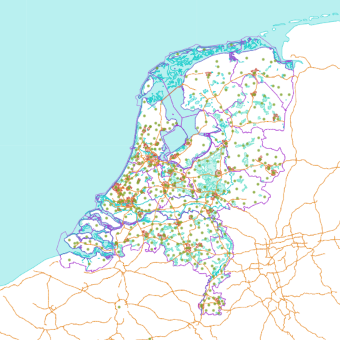
Cartiqo is a Vector Tile product based on open source geo data of the Netherlands. It provides a full and detailed map of the Netherlands customizable to your own likes.
Explore the tileset in the interactive map viewer, check the date of the last update, use it as vector tiles, etc.
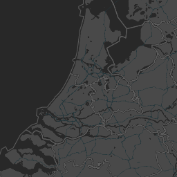
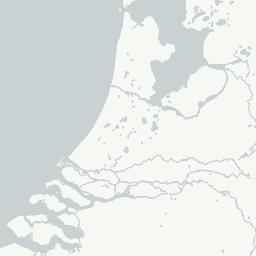
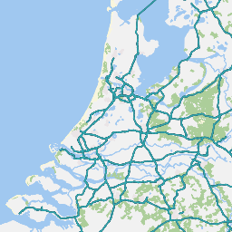
Maps with this tileset
Definition of layers
The NL Cartiqo tileset contains the following layers:
agricultural #
All fields for agricultural purposes, including pastures, greenhouses, arboriculture and fallow.
Together with the layers natural, infrastructure and builtup it covers the total surface of the Netherlands from zoom level 13 and higher.
Fields
originalID
type
The main type of the feature.
Possible values:
agriculturearboriculturepasturegreenhousefallow
subtype
Possible values:
agricultureorchardfruit
arboriculturenursery
pasturegreenhousefallow
boundaries #
Administrative boundaries of countries, provinces and municipalities. Will be expanded with regions and neighborhoods in the next editions.
Fields
originalID
name
type
The main type of the feature.
Possible values:
countryprovincemunicipality
subtype
Possible values:
countryforeigndomestic
provincemunicipality
waterline #
Contains all the urban areas and buildings.
On lower zoom levels a city is represented as an urban area and on higher zoom levels the areas will be split up into
building blocks and later by buildings and even more detail, entrances, walls and covers.
Together with the layers natural, agriculture and infrastructure
it covers the total surface of the Netherlands from zoom level 13 and higher.
Fields
originalID
name
type
The main type of the feature.
Possible values:
areabuildingwall
subtype
Possible values:
area- ` `
courtyardindustrialresidentialgraveyard
building- ` `
industrymainbarnentrancewaterbassincoverpitchberth
wall
infrastructure #
This is NOT the road infrastructure. But physical areas, human-made which are not natural or vegetation covered.
Mostly asphalt or stone coverages, often found inside urban areas. Areas supporting the road infrastructure.
Together with the layers agriculture, natural and builtup it covers the total surface of the Netherlands from zoom level 13 and higher.
Fields
originalID
name
type
The main type of the feature.
Possible values:
parkingroadrailwayjettytunnelbridgerunwaypavement
subtype
Possible values:
parkingroadmotorwaytransitbikedrivewaybridle_Waycrossingsecondaryhighwaylocalpath
railwaytrack_surfaceplatform
jettytunnelbridgerunwaypavement
labels #
Names of areas, usually displayed only as a label (not an icon). Larger areas with natural names of undefined borders and administrative areas. Also including address numbers at zoom level 16.
Fields
originalID
name
type
Possible values:
place- Place names of inhabited places like cities, large towns, small towns and hamlets in the Netherlands. Also including urban district names as used by inhabitants (different form administrative districts).admin- Administrative names from administrative areas according to the CBS. Placed as a point inside the area.water- Relevant water names of physical areas. (not harbors)nature- Relevant nature area names. Only large nature areas. (not gardens and dog parks)adress- Address numbers and letters, available at zoom level 16.junctionmilestonestreet
subtype
Possible values:
placeurban_districtsettlement
admincountryprovincemunicipalitydistrictneighborhood
waternatureaddressjunctionmilestonestreet
hierarchy
Place label hierarchy. Based on capitals, population size, category and geometry type. e.g. polygons have a higher hierarchy then points. For a detailed overview see the document Label_hierarchy.ods
Possible values:
12345678910111213
rotation
Rotation of address numbers in degrees. Only for type == address. Possible values from -90 to 90.
natural #
Contains all nature polygons like nature areas, grass fields and forest areas.
It describes the physical material of the land surface.
Together with the layers agriculture, infrastructure and builtup
it covers the total surface of the Netherlands from zoom level 13 and higher.
Fields
originalID
type
The main type of the feature.
Possible values:
high- is all natural vegetation like trees and forest areas. Including tree lines.low- covers all natural vegetation defined as grass, heather and shrubs.bare- are features describing natural areas without vegetation like sand areas: dunes and sand and rock plains.
subtype
The subtype of the feature describes the type in even more detail and can be used to make more distinction in the map styling.
Possible values:
highmixeddeciduousconiferous
lowheathgrassshrubs
baresandrockdune
pois #
Points of interest which usually are visualized with an icon. Human-made functionality or human agreements that define a distinct place of reference.
Fields
originalID
name
type
Possible values:
food_drink- All food and drink occasions.public_building- A public building with general purposes.public_space- Public areas which are not buildings but fields or areas with a functionality. Like a harbour, industry, dog park or playground. Nature areas which describe physical areas are not in this layer but in Labels. POIs describe an area with a human decided function assigned.public_transport- Public transport stops.commercial- Commercial shops other then food and drink.
subtype
Possible values:
food_drinkdrinkfood
public_buildingcultureeducationhealthcarepublic_building
public_spaceindustrygreenparkingsportwater
public_transportairportbus_stopferry_terminalmetro_entrancetrain_stationtram_stop
commercialgroceriesconveniencefuel
subsubtype
The subsubtype of a POI feature is the original description from source data the POI is derived from. (mainly OSM)
hierarchy
The label hierarchy or size/importance per POI category. Top10NL data is considered priority. Then Polygon sources and larger areas. Then POINTS Most features must contain a name to be considered in the data. Except for the Parking places. Which are hierarchical ordered according to having a name or not. Parks are also hierarchical ordered to name and area size. See POIs_decision.ods for a complete overview of the decisions made.
Possible values:
12345610
railways #
Fields
originalID
type
The main type of the feature.
Possible values:
railtrammetroindustrialtouristiclight_rail
tunnel
If line feature is tunnel or not.
Possible values:
truefalse
roads #
Fields
originalID
name
type
The main type of the feature.
Possible values:
highwaymotorwaymainsecondarylocalbikepathferry
tunnel
If line feature is tunnel or not.
Possible values:
truefalse
oneway
Possible values:
-101
road_number
Dutch road number classification if available. Like A roads and N road numbers. These roads often contain a name and a number, so this can be used for double labeling.
water #
Contains all water area polygons like oceans, sea, lakes and rivers. On lower zoom levels it contains all oceans from the Natural Earth data set. At higher zoom levels it contains all water bodies from The Netherlands. Including the Wadden.
Fields
originalID
name
type
The main type of the feature.
Possible values:
seatidal_flatlakewater_way
waterline #
Water streams in Dutch geo data sources are sometimes drawn as a Polygon and sometimes as a Line. Therefore a separate layer for water lines is provided. Note! a water body or stream is not defined by the geometry. Water streams can be drawn as a line or a polygon. Water bodies are often given as polygons but also larger rivers are given as polygons. No explicit reasons can be found for this difference. Mostly water drawn as lines are smaller water streams like ditches between fields.
Fields
originalID
name
type
The type of water line is the width given by the source data.
Possible values:
3m6m12m50m125m
License
With the use of this API, you must visibly credit these attributions: